Oh, McKenny Street! What a tiny little street that no one talks about anymore. Until a few years ago, you wouldn’t even find it on any street sign. But it has lived on official city maps for over 200 years.

McKenny Street is (mostly) parallel to, and one block to the west of, Hicks Street, in the oldest part of Brooklyn Heights that grew out of the Fulton Ferry Landing area. McKenny originally ran 2 short blocks from Doughty to Poplar Streets. Since the 1950s when the BQE obliterated several blocks around Squibb Hill in the far northwestern corner of the Heights, McKenny has run only from Doughty to Vine Streets.
McKenny was basically an alley to Hicks. Most of the properties on Hicks ran straight back to the east side of McKenny, sometimes with an outbuilding fronting on McKenny…only the Doughty and Poplar corners had separate buildings on the east side of McKenny that weren’t connected to Hicks. And the west side of McKenny mainly consisted of the sides of buildings on Doughty, Vine or Poplar. Of course, all these buildings are long gone.
I think McKenny Street was opened up when the Hicks brothers laid out the North Heights right after 1800. Most of the land that is now Squibb Hill was a separate farm owned by Cary Ludlow (and not immediately turned into development lots), so creating McKenny allowed access to some of the land up the hill, south of Doughty, that would otherwise be too far from a street to allow a saleable lot where an accessible building could be constructed. The Hicks-McKenny block on the Poplar side is slightly shorter than the Doughty side because of the original shape of the Ludlow farm boundary.
Supposedly the street is named after a John McKenny, who was an eighteenth century Brooklyn constable, or Roman Catholic leader (or both). Records are sketchy.
Until about 5 years ago, at the corner of Doughty and McKenny, the McKenny side suffered the indignity of having a “Hicks Street” sign (across from the New Xcell car repair shop, by the east side of the old JW building at 29 Columbia Heights). But it was always labeled accurately on the city’s official maps. When New York City replaced street signs with lowercase versions to comply with Federal law, someone at DOT realized the corner was mislabeled, because a new “McKenny Street” sign was introduced. (On Google Streetview, the September 2014 image shows “Hicks Street” at the corner but by the December 2017 image, the new “McKenny Street” sign was up.)
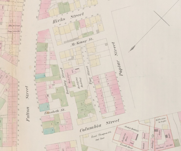
The earliest maps spell it McKenny (check out the 1855 Perris fire insurance map above) and so does the current city map. Some other maps spell it McKenney (like the 1916 Hyde atlas).

In researching my family from Ireland, the early Brooklyn McKenny’s were from Dromara, County Down. They were in Brooklyn in some numbers before 1800 and some, like my gggg grandfather made money, returned to Ireland as “gentleman” and led a fine life. I found that McKenny Street was named after Constable John McKenny, reportedly the first Brooklyn constable. He married a noted widow and lived on what was to become McKenny Street, hence the name I suppose.
Crazy that the smallest street in Brooklyn still has history! Thank you for sharing!